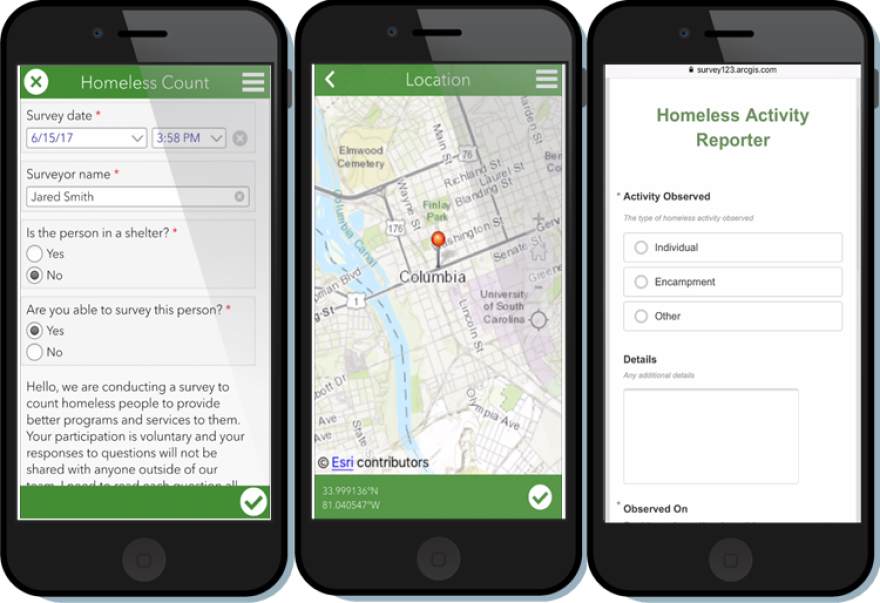
Inland Empire-based international mapping company Esri has developed software that's been used in local communities' annual Point-In-Time homeless counts. KVCR spoke with Chris Thomas, Director of Markets at Esri, to learn more about their software. Here's KVCR's Katie Trojano with the story.
Esri is a leading geographic information system company, headquartered in Redlands.Chris Thomas explains how Esri began thinking about how their company’s technology could be implemented in health and human services fields.
“Once you understand the power of location, the way you address a problem or the way you address issues, your perspective changes and I think that's what I'd kind of like to add to what the value of our technology in the hands of the people who do the real work makes a real world of difference.”
ArcGIS is a geographic information system used for working with maps and location.
By using ArcGIS as their foundation, workers at Esri have developed software tools and techniques to organize information from a geographic perspective.
Instead of using tables and charts based solely on a unique identifier-- for example, a driver’s license number or Social Security number-- Esri’s technology takes advantage of using geographic location when compiling data.
Chris Thomas explains:
“So if you take that same address as an example, on say your driver's license you combine that address and use the uniqueness of the license number and your name you can begin to connect the address back to other databases that were not intended to work with each other. If you take that same driver's license you have the ability to drill down to the city, the county or the zip code, all of those are geographic links that you can connect and demonstrate the data on a map or analyze it in the context of where it actually is.”
This allows nonprofit agencies that use Esri’s software to collaborate more efficiently and consistently. Esri’s application, Survey123, has been used for the first time in lieu of pen and paper in San Bernardino and Riverside county’s 2019 Point-in-Time count. Imperial, San Diego, Los Angeles, and Orange Counties are also among early adopters of areas using Survey123 for the annual count. Point-in-Time is an annual nationwide initiative to count the country’s sheltered and unsheltered homeless populations.
Thomas explains the benefits of using the mobile-field data collection tool Survey123 in the Point-in-Time count.
“Once the data is collected on say an Iphone or any smart device it collects the location at the same time, once that's collected it can go into a data repository a central information center and once it gets there I can now put that into our core tools to do high-end analysis like looking at how people travel, a person's location in proximity to a clinic of a county facility and then we've created what we call operations dashboard, all off ArcGIS.”
Thomas points of the importance of the patterns and trends that are identified when the day-to-day movement of homeless individuals are analyzed.
“So we see 2 or 3 different patterns, we see where certain types of people congregate that are way far away from the types of services that they need. We see that in some places they may build encampments along riverbeds and in kind of remote areas that we need to be able to get to. And then we actually see that 3rd pattern where you actually can see the major travel patterns that a homeless person goes to get the services and support they need day in and day out.”
Survey123 does more than just enhance efficiency in collecting data, emphasis on physical location makes it easier for federal and aid-based organizations to respond in a more immediate way to issues. The technology allows communities to see geographically where need is the greatest, and determine the best approach for connecting people with the resources they need.
“What we started to look at was this notion of looking at homelessness almost as if it were responding to a national disaster. Before, there were a lot of programs and tactics in place, but there's a shift to try to solve the problem in a more immediate response”
Chris Thomas says that spatial analysis is key in being able to apply understanding to solving social problems. As Esri’s Director of Markets, he says Esri’s slogan of “The Science of Where” may be more widespread in the future.
“We're gonna see things down the line where the design of a city and the design of how we place social services will be based on location and it will be built into the fabric of how we solve these types of crises.”
For KVCR News, I’m Katie Trojano.


